
Accurate rooftop assessments are the foundation of successful solar projects. Measurements, shading analysis, and structural evaluations all determine whether a design is viable and how much energy a system can produce. Many Freedom Forever Solar reviews highlight the company’s use of cutting-edge technology—such as drones and LiDAR—to modernize site planning and improve both accuracy and safety. Traditionally, site assessments required crews to climb onto roofs with measuring tapes and cameras, a process that was time-consuming, sometimes hazardous, and prone to human error. Freedom Forever Solar, one of the nation’s largest residential providers, continues to lead in adopting these advanced tools to make rooftop evaluations faster, safer, and more reliable.
The combination of drone imagery and LiDAR scanning sets new standards for rooftop solar assessments. By comparing data capture methods across accuracy, safety, and cost, companies are finding better ways to design systems, reduce risks, and keep projects on schedule.
The Limitations of Traditional Assessments
Manual rooftop assessments rely on crews physically measuring dimensions, taking photographs, and recording observations. While effective in some cases, this approach has significant drawbacks. Human error can result in inaccurate measurements, which may cause design revisions later in the process. Safety risks also increase when workers climb steep or fragile roofs.
The time required for manual assessments further adds to project costs. Crews may need hours to complete a single visit, and mistakes can trigger repeated trips. In a high-volume industry, these inefficiencies can quickly accumulate into backlogs.
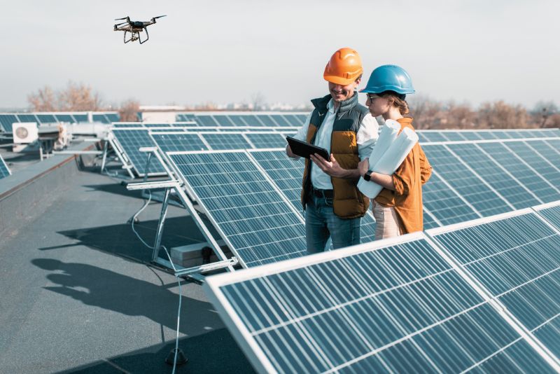
Drone Data Capture
Drones have emerged as one of the most impactful innovations in solar site assessments. Equipped with high-resolution cameras, drones can capture detailed imagery of rooftops in minutes. Software then processes these images into 3D models that provide accurate dimensions and shading patterns.
Drone surveys reduce the need for technicians to climb onto roofs, improving safety. They also accelerate project timelines by cutting assessment time dramatically. Accuracy may vary depending on factors such as lighting, camera quality, and operator skill. While drone data is often sufficient for design, it may require validation in more complex cases.
LiDAR Scanning
LiDAR, or Light Detection and Ranging, offers an even higher level of precision. By emitting laser pulses and measuring their return, LiDAR systems create detailed 3D maps of rooftops and surrounding environments. These scans capture subtle variations in roof angles, obstructions, and nearby shading elements.
For solar planning, LiDAR provides unmatched accuracy. Designers can model panel layouts with confidence, reducing the likelihood of last-minute changes or failed inspections. The downside is the cost. LiDAR equipment is expensive, and processing data requires significant computing resources. As a result, LiDAR is often reserved for more complex or high-value projects.
Safety Improvements
Both drones and LiDAR significantly improve worker safety. By reducing the need for technicians to climb roofs, companies lower the risk of falls and injuries. It is especially important in residential solar, where steep pitches and fragile surfaces are common.
Automated data capture also minimizes exposure to environmental hazards. Workers spend less time in extreme heat, on icy surfaces, or around electrical components. These safety improvements support not only employee well-being but also compliance with labor and safety regulations.
Balancing Cost and Accuracy
Across the solar industry, companies use different tools to balance accuracy and cost in site assessments. Drone surveys are often a more affordable option, requiring modest equipment and training investments. They are well-suited for standard residential projects where speed and safety are top priorities. LiDAR, on the other hand, delivers higher precision but at a higher cost. This level of detail is most valuable for complex projects, such as large commercial installations, uniquely structured roofs, or sites with heavy shading. Many providers take a blended approach, using drones for most projects and reserving LiDAR for more challenging situations.
Freedom Forever reviews frequently highlight the company’s focus on efficient systems and customer satisfaction. Industry tools like drones and LiDAR contribute to these outcomes by reducing design revisions, shortening project timelines, and improving safety for workers. For homeowners, this means a smoother project experience with fewer surprises, which builds confidence in their provider. That confidence often translates into higher satisfaction, stronger loyalty, and more referrals, reinforcing long-term trust in both the company and the solar journey.
Policy and Regulatory Perspectives
Regulators are taking note of advanced assessment methods as well. Some jurisdictions are beginning to accept drone and LiDAR data as official documentation for permitting and inspections. This shift reduces administrative burdens and accelerates project approvals.
Policies supporting digital assessments also align with broader goals of modernizing infrastructure and expanding clean energy adoption. Companies that invest in advanced data capture methods are better prepared to comply with developing standards and take advantage of incentives tied to efficiency and safety.
Equity Considerations
As with other advanced technologies, equity must be addressed. Smaller providers may lack the resources to invest in drones or LiDAR systems. Without access to these tools, they may face longer timelines and higher risks, creating disparities in the industry.
Policymakers can help bridge this gap by funding grants, shared platforms, or training initiatives that make advanced assessments accessible to all providers. Ensuring equitable adoption supports a more inclusive clean energy transition.
Economic Impacts
The economic benefits of drone adoption and LiDAR are clear. Faster, safer assessments reduce labor costs and minimize delays. Fewer design revisions translate into smoother project pipelines and higher completion rates. Customers benefit from reduced project costs and increased trust in their customers. On a scale, these efficiencies strengthen the clean energy economy. By lowering barriers to adoption, advanced assessments accelerate installation rates, expand job opportunities, and increase renewable energy contributions to the grid. Investors and financiers also value companies that demonstrate precision and efficiency, as they signal reduced risk.
Drones and LiDAR are setting a new standard for rooftop planning in residential solar. By combining speed, safety, cost-efficiency, and accuracy, these tools enable providers to streamline operations and deliver more reliable customer experiences. The challenge is integrating these technologies into everyday workflows without straining resources, while regulators can help by advancing policies that support digital assessments and uphold compliance. The result is clear. Faster projects, safer practices, and greater confidence in solar investments. The future of rooftop assessments will not be defined by a single method, but by the intelligent use of both drones and LiDAR. Together, they mark the next step in creating a solar industry that is precise, efficient, and prepared to meet the demands of a rapidly expanding clean energy economy.